How this tracker works, and how to use the data
flights.jasperhaynes.com counts the planes in the air over the US during the FAA nationwide ground stop that began on . This page explains where the numbers come from, what they can and cannot tell you, and how to reuse them.
What the tracker shows
- How many planes are in the air over the US right now, and how many of them fly with an airline call sign.
- A live map, and a replay of how fast the sky emptied after the stop began.
- Whether an airport has an FAA ground stop or delay, from the FAA's own airport status feed.
- Whether a flight number is in the air, which planes are heading to an airport, and the take-offs seen at the 40 busiest US airports.
Where the data comes from
Plane positions come from adsb.lol (data under the Open Database License, ODbL) and adsb.fi. Both collect the ADS-B signals that planes broadcast, through receivers run by volunteers. The tracker asks them for 37 overlapping circles that cover the lower 48 states, Alaska and Hawaii, about every 40 seconds.
Airport stops and delays come from the FAA National Airspace System Status feed, read every two minutes.
Usual routes of flight numbers (used for "planes heading to this airport") come from the crowd-sourced Virtual Radar Server standing data.
The banner at the top of the tracker is written by hand and checked against the FAA and news reports, with links to the sources.
How planes are counted
- A plane counts when it flies faster than 50 knots (about 58 mph) inside a rough outline of the US, Alaska or Hawaii. That leaves out planes parked or taxiing at airports.
- "Airline call sign" means a call sign of three letters followed by a number, like UAL123. That covers airlines, but also some cargo, charter and private jet operators.
- One full count takes up to 40 seconds. If an area does not answer, its last answer is reused for up to four minutes; after that the area is counted as missing, and the data says how many areas were missing.
Limits
- Volunteer receivers do not cover every place equally. Planes low over remote areas or far out at sea can be missed.
- Trackers such as FlightAware and Flightradar24 use other receivers and other rules (for example, counting only flights heading to US airports), so their numbers differ from ours.
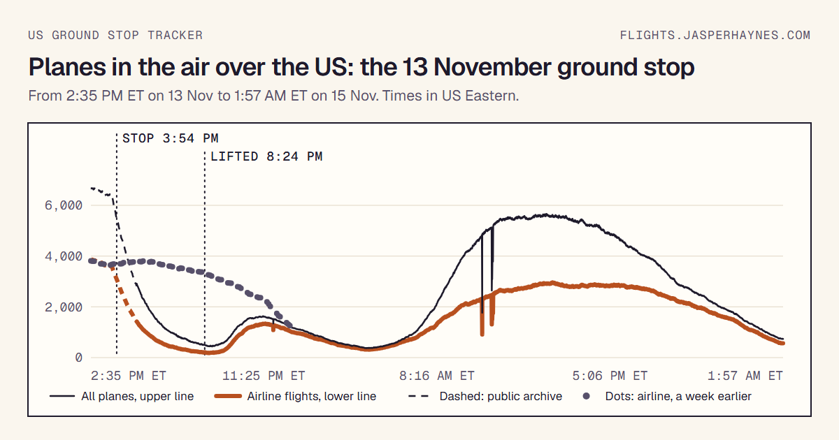
- One count is stored about every 40 seconds. In the first hour of our recording (until 6 pm ET on 13 November) it was about every 90 seconds, so that part of the chart has fewer points.
- Our recording started at , about an hour after the stop began, so the first recorded number is not the number at the moment the stop began.
- This is an unofficial tracker. The FAA and the airlines are the only official sources for whether a flight or an airport is stopped.
Downloads and how to use the data
Free to use with credit and a link to flights.jasperhaynes.com. For example: "Source: flights.jasperhaynes.com, from adsb.lol and adsb.fi data". The plane positions behind the counts come from adsb.lol under the ODbL; if you reuse positions rather than counts, follow that license too.
- Planes in the air, every snapshot, live (CSV): opens in Excel or Google Sheets.
- Snapshot as CSV and as JSON: refreshed when the site is updated; the file says when.
- The first hour of the stop (JSON): counts per minute from 3:35 to 6:05 pm ET on 13 November, made afterwards from the public adsb.lol archive with the same rules. At the overlap with our recording it counts about 4% fewer planes in total; airline flights match, so use those to compare.
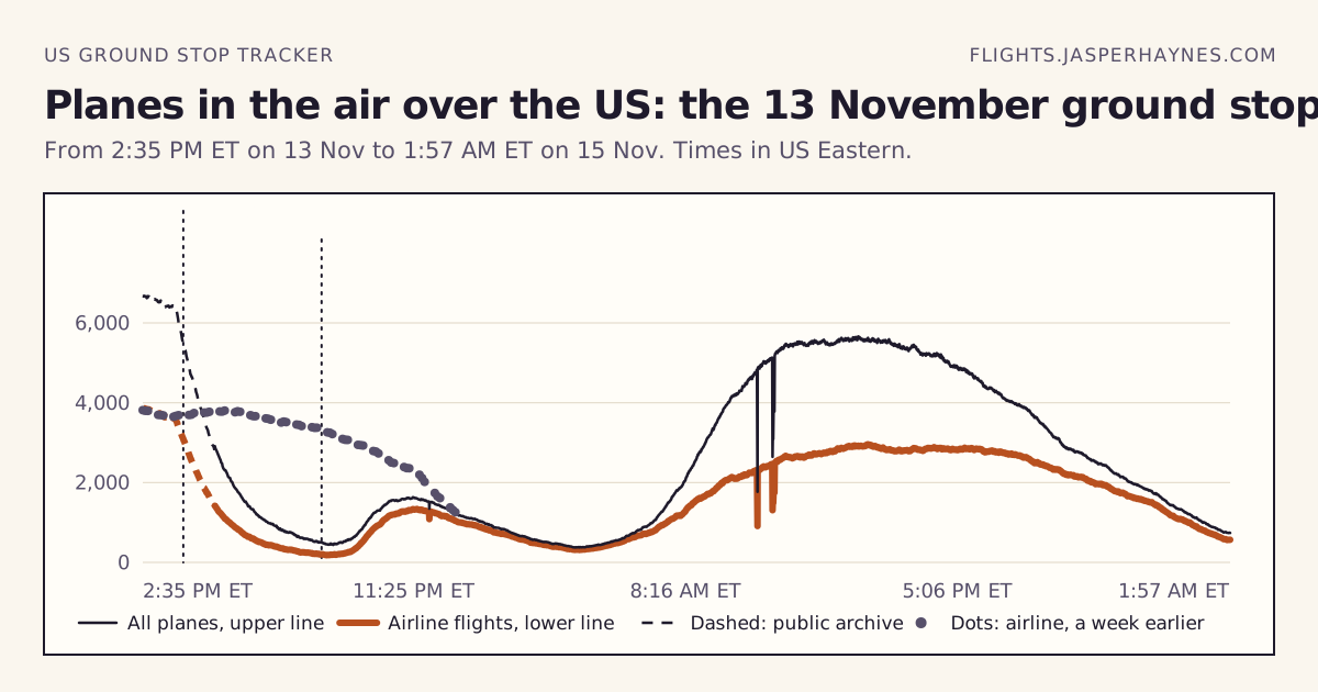
- Chart as PNG (1200 by 630) and as SVG.
- Day by day: Friday, November 13, 2026 in numbers, Saturday, November 14, 2026 in numbers.
- Live count and chart for your own site: the embed code is on Use this on your site.
The recording runs about every 40 seconds until 20 November 2026.
Who made this
Built during the ground stop by Jasper Haynes, who builds products and tools with AI. Questions about the data, or found a mistake? Get in touch through jasperhaynes.com.